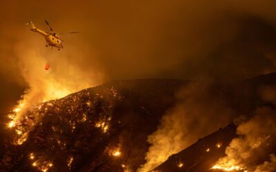
The recent LA fires have sharply highlighted the rise in severity and frequency of wildfires globally. The impact on the community and the region’s economy was devastating, with lives lost and thousands of homes and businesses destroyed in the space of a few hours. Deploying aerial firefighting technology plays a key role in combating wildfires in the USA and globally.
In this article, we will examine how aerial firefighting can be assisted by 21st-century technology, including AI and Enhanced Reality programs. We’ll look at the challenges faced by crews involved in helicopter firefighting and the potential technological solutions that exist.
We’ll also assess how systems such as FlySight’s innovative OPENSIGHT turnkey console solutions can help crews react faster, more efficiently, and more effectively to the challenges of modern firefighting.
Can technology help with aerial firefighting?
The simple answer is yes. Aerial firefighting operations teams are using new tech to assist in all areas of operations, from remotely piloted aircraft systems that incorporate drones or converted aircraft to augmented reality software that can give operators a far more in-depth understanding of the terrain and the challenges they are facing.
Technological tools such as drones are not just being used to combat wildfires and forest fires but also to facilitate prescribed burns, water drops, personnel and fire monitoring, and so much more.
The combination of cutting-edge software solutions such as OPENSIGHT brings a whole new selection of tools to the table, including software incorporating AI and enhanced reality capabilities. These turnkey solutions are designed to enhance real-time situational awareness, mission planning, and debriefing using systems that can be applied to military, civilian, and emergency services applications.
The challenges aerial firefighting operators face
Fires are unpredictable. As with the recent Los Angeles wildfires, the slightest spark can lead to a wildfire that lays waste to thousands of acres. The topography of a canyon can funnel powerful winds that fan a small flame or blow embers from one side of a road to another, allowing a fire to jump through supposed barriers and spread rapidly.
Where will the next fire occur?
Uncertainty about where and when the next fires will occur is one of the biggest challenges facing aerial firefighting crews. Helicopters are expensive to operate and have limitations in challenging environments. Knowing the location of the next fire enables operators to maximise the use of helicopter firefighting teams and ensure their safety.
To help them predict this, AI can compare historical data and spot patterns and potential vectors such as weather conditions (in the case of the LA wildfires the Santa Ana winds), and compare that to current data.
During a fire situation, thermal and hyper-spectral imaging can identify hot spots under the surface, even if the top layer of ground is apparently fully under control and cool.
Controlling rapid fire travel
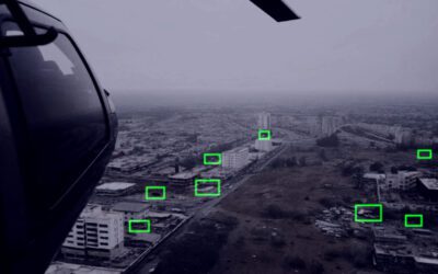
To be fully effective, aerial firefighting units need to be deployed to the right locations to prevent the rapid travel of a fire. 3D Moving maps with multiple layers combined with real-time video-over-map projection. These features are integrated into Mission Consoles that are specifically designed to support airborne units, whether that’s search and rescue, forest management or, in worst-case scenarios, firefighting.
Multiple layers provide the information analysts need to predict a fire’s movement based on real-world information and additional data such as weather updates, wind speed and direction, and so on. The key challenge is to limit the spread of rapid fire travel and prioritise which areas to address first.
Setting up rescue corridors
Escape routes for civilians and ground firefighters need to be established. The problem with a forest fire is that these routes can quickly become impassable, especially if the fire jumps from one side of a road to the other. Rescue corridors need to be secured to evacuate civilians who may be in the path of the fire while ensuring the safety and well-being of the firefighters themselves, both on the ground and in the air.
Overlayed geospatial mapping allows aerial crews to work out safe escape routes from the air and then direct ground crews accordingly, utilising Augmented Reality layers to give them an accurate assessment of the ground.
Keeping the lines of communication open
The essential requirement is clear, concise and, above all, accurate information that can enable firefighting crews and coordinators to make the right decisions quickly. Therefore, the information relayed to them by equipment such as remote drones is essential, as is satellite data, topographical information, and even data on the geology and botany of the region. For example, fir and spruce trees can be more combustible than deciduous trees. The sap in a fir tree can be particularly difficult to control if it ignites, as the chemical composition of the sap creates a longer burning fire that is harder to extinguish.
Data like this needs to be collated quickly and presented in a way that enables helicopter firefighting crews and ground crews to coordinate their response and react in real time to a rapidly changing scenario. In this instance, AI can help gather, sort, and present relevant data while eliminating background noise or spurious information that contributes nothing to the operation.
A clearer picture
One tangible challenge that helicopter firefighters can face is a simple one of visibility. In a fire, the amount of smoke in the air can cause a serious haze that can be almost impossible to see through and shield vital visual references for the operators. In this case, anti-haze technology can assist in giving operators a more precise visual representation of the geography of the terrain.
Fog Suppression or image de-hazing uses sophisticated algorithms that identify areas of an image affected by haze and then apply targeted enhancements to increase the contrast and clarity. The result is a much clearer image of the terrain – essential to those involved in evacuating civilians from a hot zone or for analysts to locate practical points to construct fire breaks.
Vegetation management – OPENSIGHT expands the toolbox in the fight against wildfires
OPENSIGHT is instrumental in mitigating wildfires through its advanced AI-powered capabilities, augmented reality visualisation, and real-time situational awareness solutions. A toolbox of functions provides the key to vegetation management, which in turn can drastically reduce the possibility of wildfires taking hold.
Key features include:
- AI-Powered Vegetation Management—OPENSIGHT uses advanced AI-powered software to detect existing risk areas, predict future risk areas, and assist with disaster management.
- Earth Observation Satellite Imaging – The system collates Earth Observation (EO) satellite imaging to acquire data without the need for on-ground inspections. This data can be compared with historical images to detect changes in vegetation and assess the extent of those changes.
- Real-time Risk Assessment – The information gathered from satellite imagery feeds into the AI-powered platform, which assesses risks and provides detailed insights to inform vegetation management decision-making. This proactive approach helps prevent wildfires near high-risk areas such as powerlines.
- Minimising Infrastructure Safety Concerns – All of this can contribute to minimising infrastructure safety concerns, including damage to essential utilities. By maintaining adequate clearance around power lines and other critical infrastructure, OPENSIGHT helps prevent fires in high-risk areas such as Southern California’s arid valleys and canyons.
Learn more about OPENSIGHT
Other articles that might interest you:
🔗 Effective Vegetation Management for Utility Companies
🔗 Training for Search and Rescue Mission Using AR Technology
🔗 Search and rescue Technology of the FUTURE – How Tech is Helping Target Recovery with New Features
🔗 Mobile phone detection, location and communication systems in airborne Search and Rescue
🔗 Aviation Mission Preparedness and Planning – Mission Planning System Features