A Close Look at Geo Remote Sensing Technology and the Benefits and Applications of Remote Sensing Technology in Helicopters
A clear and detailed appraisal of your surroundings is essential for helicopter pilots and operators. However, the limitations of space and the already complex nature of a helicopter cockpit have traditionally placed certain restrictions on the type and amount of additional software that can be installed as operator aids. Today, though, remote sensing technology (RST), particularly geo-remote sensing, provides pilots and operators with a whole new portfolio of Enhanced Reality aids.
In this article, we’ll look more in-depth at geo-remote sensing technology and how it differs from other operating systems, such as hyperspectral and geospatial imaging. We’ll investigate its role in the modern helicopter cockpit and the advantages it offers both military and civilian operators. We’ll also take a closer look at FlySight’s innovative OPENSIGHT system which incorporates optical remote sensing as part of a turnkey solution to the challenges faced by military, SAR and law enforcement operators in particular.
What is wide-area remote sensing technology?
Remote sensing technology allows operators to acquire information about an object or phenomenon without making physical contact. It does this by measuring the reflected and emitted radiation. It often involves the use of satellite or aerial imagery, with the information gathered by cameras, sonar systems, and other advanced monitoring systems such as radar and LiDAR.
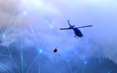
Wide-area sensing expands that to a much larger area, collecting data using a variety of platforms, including helicopters. The information gathered can prove invaluable within the confines of a mission, especially as the data can be gathered and analysed in real-time. This can provide units with information on anything from an unfolding environmental disaster or catastrophe to large-scale disorder within a complex urban environment.
Remote sensing utilises specific types of technology, ranging from LiDAR to Synthetic Aperture Radar (SAR) and interferometry SAR (InSAR). Other technologies, such as hyperspectral imaging and geospatial technology, are often grouped with remote sensing technology.
However, it is essential to differentiate between the various components. While all hyperspectral imaging is remote sensing, not all remote sensing is hyperspectral. Some types of optical remote sensing work in narrow bandwidths, filtering out background ‘noise’ to give the end user a cleaner, more accurate picture of the targeted terrain.
By contrast, geospatial technology is a range of technologies used to collect, analyse, and store geographic information. This includes Geographic Information Systems (GIS), Global Positioning Systems (GPS), and remote sensing. Of all the wide-area remote sensing technologies, this is the one that the majority of people are most familiar with. It interlocks easily with other remote sensing technologies and creates a cohesive and wide-ranging spectrum of imaging capabilities both on land and over water.
How Geo Remote Sensing Technology works
The equipment used in geo-remote sensing technology gathers large amounts of data that accurately maps terrain elevation and objects. This can be applied to both open space, urban areas, and oceanic locations. The position of optical remote sensing technology will depend on the platform used. Orbital sensors on satellites are generally located in low, medium and high-earth orbit satellites. Those in high-earth orbit at altitudes of 35,000km above the earth’s surface are in geosynchronous orbit and cover huge distances.
Remote sensing technology offers a spectrum of capabilities, with trade-offs between orbital and low-altitude platforms. Geostationary orbit sensors, while continuously advancing, face resolution limitations due to their extreme distance from Earth. These orbital systems play a crucial role in providing mission-critical data across various applications. However, for immediate and highly detailed terrain information, platforms like helicopters offer superior capabilities.
Resolution quality is a key factor in remote sensing, quantified by radiometric resolution. This measure indicates the information capacity of each pixel. Higher radiometric resolution translates to greater information storage capacity, allowing for more nuanced data representation.
Data collection in remote sensing spans an extensive frequency range, from radio to gamma waves. The focus often lies on frequencies encompassing visible light, infrared, and ultraviolet spectra. While hyperspectral sensors can detect a vast array of wavelengths, this breadth can sometimes compromise image quality. In contrast, optical remote sensing technology that concentrates on narrower frequency bands and fewer spectral channels often yields sharper resolution and enhanced detail.
The choice between broad spectrum (hyperspectral) and focused spectrum (multispectral) sensing depends on the specific application requirements, balancing between the breadth of data collected and the clarity of the resulting imagery.
Remote sensing technology for helicopter operators – how it helps performance and mission outcomes
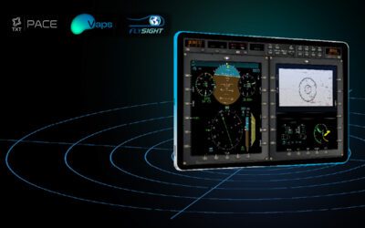
Remote sensing technology gives pilots and copilots a better understanding of their environment and improves visibility, even when conditions are less than optimal. FlySight’s advanced OPENSIGHT system is a primary example of how this kind of technology is being enhanced in aerial platforms.
This is currently being integrated into mission consoles typically found on board helicopters, and is most frequently located behind the pilot’s seat console. The TFO can provide data that delivers enhanced situational awareness. Not only does this improve the chances of mission success, but it is also important for the safety of the crew and the aircraft.
Improved visibility from OPENSIGHT remote sensing technology enhances images and produces video in real-time. The system allows users to access video and images improving the quality of the image through AI processing, such as dehazing, Fog Suppression Retinex technology, image stabilisation and other enhancement, and Georeferencing Push-Broom Data capabilities. This enables the operator to acquire optimal visual input for decision-making purposes.
RST also enables the Tactical Flight Officer to focus on the flight rather than gathering data. There are fewer tasks to complete and, therefore, fewer distractions. Thanks to the use of AI within the OPENSIGHT system, the operator effectively has a ‘third man’ in the cockpit carrying out data and spectral analysis while they focus on flying the aircraft.
The platform can limit the number of features on display at any time, selecting only the information that the operator considers useful and without any kind of background distraction from deviant or unnecessary information.
Remote sensing also gives helicopter pilots and operators improved depth perception and a much better understanding of terrain topography. The increased visual range of the technology, particularly wide-area sensing technology, provides far more information as it can see much further than the human eye and includes spectrums that human operators cannot see (such as the infrared spectrum).
It allows accurate mapping of terrain elevation and objects, both in urban and rural landscapes, making it useful for everything from surveillance and crowd control operations to Search & Rescue. The ability to combine Enhanced Reality and AI as well as software overlays improves the diversity and flexibility of a remote sensing helicopter setup.
The key takeaway is that the most modern of these systems are exceptionally compact and use a ‘plug-and-play’ configuration, which can be easily grandfathered onto existing mission systems. This is the core of the OPENSIGHT Mission Console.
OPENSIGHT advanced system integrates state-of-the-art multispectral imaging and sensor processing, and data exploiting with edge computing and AI-enhanced. This fusion delivers unparalleled tactical intelligence, surveillance, and reconnaissance (ISR) solutions, optimized for diverse, real-time and mission-critical operational scenarios.
Mission Console is a seamless fusion of avionic sensors data capture and integration that provides essential data for navigation, communication, and safety. These sensors gather information from various sources, including radar systems, GPS, altimeters, and airspeed indicators, to ensure accurate and reliable data for pilots and onboard systems. The data collected from these sensors is crucial for maintaining situational awareness and operational efficiency. OPENSIGHT, a versatile integration platform, is designed to seamlessly interface with a wide range of avionic sensors and radar systems. This compatibility ensures that data from diverse sources can be effectively consolidated and utilised, enhancing the overall functionality and performance of avionic systems.
Find out more about OPENSIGHT
Creating dynamic and customisable Mission Console systems is at the very core of OPENSIGHT. Recently, a new inclusion into the Console matrix represents a major safety feature for pilots, namely the Terrain Above Elevation (TAE) capability. This is a perfect example of how optical sensor technology can not only enhance the mission success ratio but also ensure the safety of the vehicle and the operators.
You can learn more about the TAE system here, and you can learn more about our remote sensing technology solutions for helicopter operators. To learn how OPENSIGHT can bring a whole new level of enhanced reality and extended sensory technology to your system, contact us and talk to one of our expert technical today.